Part Four of Into the West is the continuation of a multi-part series that chronicles the journey that Shelley and I embarked on in late August and early September. A journey that covered over 5,000 miles, seven states, and two provinces of Canada over the course of about two weeks. If you missed out on Parts One through Three click here to get caught up.
Day Six
Shelley and I awoke again to the breathtaking view at the cabin west of Yellowstone near Island Park, Idaho. Day six of the journey was our last full day in Yellowstone National Park. And we still had a lot to cover. This was to be yet another long day, as it turned out it was even longer than we hoped, lasting into the early morning hours of Day Seven.
We entered Yellowstone earlier than on Day Five and set our sights on making it to Tower Fall, which is a little more than halfway to the northeast entrance to the park.
NORRIS GEYSER BASIN
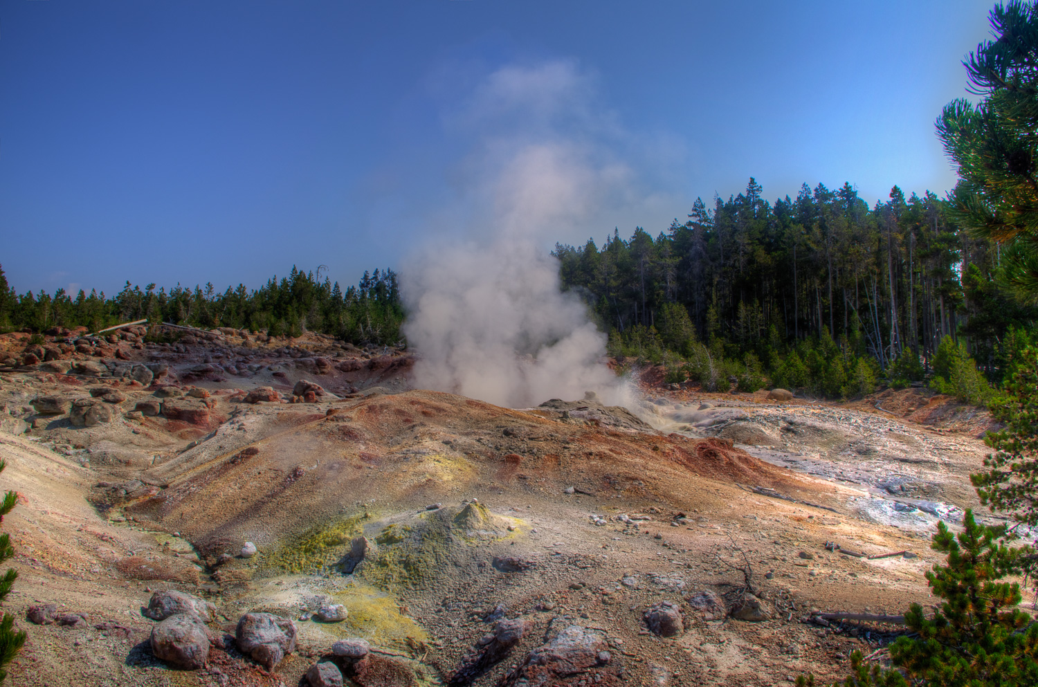
Our first stop of the day turned out to be the Norris Geyser Basin. This basin is home to Steamboat Geyser, as well as many other geothermal features. Steamboat Geyser is by far the most active of the features located in the Norris Geyser Basin.
There are a few things to keep in mind when walking through the geyser basins of Yellowstone. First, almost all of them will have the smell of rotten eggs. The intensity of the smell can greatly change from basin to basin and is also affected by the speed and direction of the wind. The second thing is, bring at least three different types of footwear. The third is, take in the beauty that is surrounding you in this natural place. And the fourth is, stay on the marked trails!
Our first stop while walking through the Norris Basin was of course Steamboat Geyser. This was on the must have list of photographs for this trip. Even if it could be the only photograph made in the Norris Basin it would have been well worth it. Steamboat Geyser is currently the world’s tallest geyser, with eruptions shooting over 300 feet into the air. The last major eruption occurred in 2005, prior to that there were a series of major eruptions starting April of 2002 and ending October of 2003. Minor eruptions occur much more frequently, usually dozens per day.

We actually managed to walk all but the Porcelain Basin area of Norris-oh well, maybe next time. By the time we finished walking the bulk of the Norris Geyser Basin it was lunch time, so we scouted the map for the nearest picnic area and made our way there.
The Caldera Rim
After lunch we continued toward our goal of making it to Tower Fall. Along the way I had hoped to stop at Virginia Cascades, but the area was closed for one reason or another. After turning north onto the Grand Loop Drive (east side of the loop) we started to climb the side of a mountain. About half way up the climb we came to a roadside pullout. We pulled off and were rewarded with a panoramic view of the Yellowstone Caldera. This pullout was the only view that we saw while journeying through Yellowstone where it was possible to understand the size of the volcano’s caldera. Other than seeing highly detailed images from space, this may be one of the only places on the planet where one can get an idea of the vastness of it.

Tower Fall
After pausing for the view we continued up through Dunraven Pass and onto Tower Fall. Tower Fall was renamed by the United States Geological Survey in 1928 from Tower Falls. Tower Fall is a 132 foot plunge type of waterfall.

Upper and Lower Falls of the Yellowstone River
Shelley and I left Tower Fall and turned back south along the section of Grand Loop Road that is also known as Tower-Canyon Road toward Canyon Village. The next goal for the day was the Upper and Lower Falls of the Yellowstone River and the view of the Grand Canyon of the Yellowstone.
We arrived at the parking lot for the Lower Falls and proceeded to walk down the pathway to the brink of the falls. Along the way, down the switchback path, we meet a new friend who was very photogenic.

After making a few portraits of our new friend, we continued down the switchback to the brink of the Lower Falls. Once Shelley and I made it down to the brink of the lower falls, the colors of and sound of the water plunging over the edge were both vivid and loud.

When on a trip of any kind, one must remember that when you walk down a few hundred feet on a switchback trail, that you’ll also need to walk back up. It’s all about pacing. After reaching the parking lot at the top of the climb, Shelley convinced me to walk along the North Rim Trail to the overlook where we should have been able to view the brink and the base of he Lower Falls. After walking about another mile over trails, we came to another parking lot. To which I decided that we should walk back and drive the vehicle down to this new-found parking lot. So back we went. After driving the vehicle down to the north overlook parking lot, we walked to the overlook.

Inspiration Point
The last stop that we made on the North Rim Drive was Inspiration Point. When Shelley and I reached Inspiration Point the sun was in and out of the clouds and it looked like rain was coming, but fortunately it never did. There was still plenty of light in the sky for making photographs. I took serval bracketed exposures here in the hopes that either one would be perfect or that I could get an interesting HDR (High Dynamic Range) photograph after the fact. What I ended up with looks more like a painting than a photograph, but I still remember the colors of the canyon walls looking alive and the waters of the Yellowstone River flowing with green in them.

Shelley and I left Inspiration Point for the journey to South Rim Drive and views of the Upper Falls. While the views were good, I feel that the Lower Falls offer better angles.

Hayden Valley
The next stop on our journey for the day was the Mud Volcano area of Yellowstone National Park. Along the way we passed through Hayden Valley, albeit very slowly due to the buffalo. They seem to believe that the roadways in the park have been built just for them. Of course, even if the National Park didn’t gave them the right-of-way, I would still give an animal that weighs more than most vehicles the right-of-way. Most of the pull offs in Hayden Valley were full of park visitors waiting to see the resident grey wolf pack attempt a hunt that evening. We were able to find a pull off that afforded us a great view to the north through the valley with the sinking sun to our left.

Sulphur Caldron
Shelley and I reached the Sulphur Caldron of Yellowstone just a couple of hours before sunset. If you have never been to a mountainous area, then you may not be able to truly understand the issues that are involved with attempting to photograph landscapes and nature when the setting sun is located directly behind a large hill that contains trees that are so dense that what little light might be available is not able to brake through to your subject. The Sulphur Caldron lives up to its name. The air in the area is filled with the rank smell of rotten eggs attributed to sulphur, but the steaming vents and the colors are worth the time to see it.

Mud Volcano
Just to the south, and on the west side of the road, is the Mud Volcano area. This area has many geothermal features, of which Shelley and I were only able to see a few. The Mud Volcano itself and Dragon’s Mouth Spring. The remaining features in the area will need to wait for another trip, because the sun was fading and this would be our last day for exploring this far south in Yellowstone.
DRAGON’S MOUTH SPRING
Dragon’s Mouth Spring was named some time around 1912. And after watching the feature for a few minutes one can imagine how it came to be named. The lapping of water out of the feature brings to mind the motion of a tongue. And the steam give the impression of breath on a cold winters day, even in the middle of the summer. Add to that, the constant ‘roar’ coming from the cave and one can see that this feature is aptly named.

Yellowstone Lake
When at last we reached Yellowstone Lake the sun was just above the western horizon and reflecting off the clouds that were moving over the lake.

The Angel Wolf
Of all of the people, places, and wildlife that we saw on our journey into the west, the one that I truly wish we had a photograph of is the lone wolf pausing in the road in the pitch of night. This image still comes to mind in the dark of the night and the lesson that it retaught me. Never pack away your camera when driving through the natural beauty of the world while on a photography road trip. In any case, I feel the need to include the sighting of the wolf because she slowed us to a stop on the way back north through Yellowstone that night. This pause in time kept Shelley and I from harm that night. If not for that brief pause, we likely would have been the ones involved, rather than the car that was two cars ahead of us, in a head-on collision just north of Biscuit Basin on the west side of the Grand Loop Road. If you are going to Yellowstone remember that the roads are narrow, there is wildlife all around you, and the speed limit is to be followed at all times.


